

Folders |
2008 Leadville 100 mile Race Report
Published by
Leadville 2008 100 Miler Race Report
“You’re better than you think you are and you can do more than you think you can.” These words proved to be my motivation to complete my fourth Leadville 100 miler. I ran through rain, hail and snow to see that beautiful finish line. Here is my aid station-to-aid station of the race.
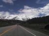
Start to May Queen (13.5 miles): Lightening and thunder was all around us when I began the race. This first section I take slow to prepare my body for the long day. I felt tight in my calves and hamstrings. I tried to get into good position before the trail went to a single track. I knew the weather was going to be a factor this year. Arrived at May Queen at 2:00 Elevation range: ~ 9,600-10,200 feet
May Queen to Fish Hatchery (10 miles/23.5 miles cum): The rain just started I was heading up to Sugarloaf Pass. I threw a couple of slow jogs in but mostly walked up to 11,000 feet. I got rid of my rain jacket and headlamp at the aid station. Arrived at Fish Hatchery at 3:50. Elevation range: ~10,000-11,200 feet
Fish Hatchery to Halfmoon (7 miles/30.5 miles cum): Ah the short flat section with pavement for 4 miles it is time to pick up the pace. Rain was coming down heavy at this time hard to see. At this time I remember my experience growing up in Indiana where it would rain all day long. I remained focus on my goal to the next aid station. Arrived at Halfmoon at 5:00. Elevation range: ~9,400-9,900 feet
Halfmoon to Twin Lakes (9 miles/39.5 miles cum): This is a difficult section to follow, because of the number of intersecting trails and roads. The rain stopped and sun popped in and out. Arrived at Twin Lake at 6:50. Elevation range ~9,300-10,400 feet
Twin Lakes to Winfield (10.5 miles/50 miles cum): Crossing the cold water sections after the getting out of the Twin Lakes aid stations was a welcome relief to my aches and pains. The deepest crossing was about hip high and coldest of the sections. This part of trail is a constant climb up and up to Hope Pass. I had to constantly keep moving to see any process. When I reached the top of Hope Pass it started to hail; pea size at first then marble size. I got hit on the head with a few of the marble sized ones and it hurt. I began to think what hell I could be sleeping in a nice warm bed right now. But alas I am an Ultrarunner. Arrived at Winfield 9:51. Elevation range: ~9,300-12,600 feet
Winfield to Twin Lakes (10.5 miles/60.5 miles cum): Finally pacers to help me out. My friend Liz joined me for the 10.5 mile trip back to Twin Lakes. Out the aid station is a nice flat, slightly downhill section before heading back to Hope Pass. I felt pretty strong on this section running the whole thing. As we began the climb I felt tired with no energy at all. Actually the sun was out and this time and I was sweating pretty well. The trail became muddy and slippery from the melting snow and hail. I fell about 2 times but ran strong into Twin Lakes at 12:43. Elevation range: ~9,300-12,600 feet.
Twin Lakes to Halfmoon (9 miles/69.5 miles cum): I was feeling pretty strong and was joined by my next pacer and friend Alyson. This section has some downhills which were hell on my quads but when we got to the flats we kick it! Arrived at Halfmoon 14:57. Elevation range ~9,300-10,400 feet
Halfmoon to Fish Hatchery (7 miles/76.5 miles cum): Flat and pavement I hate to say it but it was a welcome site. Sherri joined me and made me run the whole thing. She was a slave driver but kept me focus. Arrived at Fish Hatchery at 16:08. Elevation range: ~9,400-9,900 feet
Fish Hatchery to May Queen (10 miles/86.5 miles cum): My new pacer Pam joined for a section that has the last of the big climbs. Pam got sick about 3 miles in so I was by myself. I kept a steady pace up the climbs. Thunder and lightening all around and then the hail started again. Last section was downhill but the rocks were wet and slippery. It was an adventure trying not to fall. Arrived at May Queen at 18:54. Elevation range: ~10,000-11,200 feet
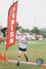
May Queen to Finish (13.5 miles/100 miles cum): Sherri returned for another round of pacing. This section is always a problem for me but with Sherri showing me no mercy pushed me. My legs said go screw yourself but Sherri said “Let’s run!” No one passed me and was able to achieve a new PR of 21:54:12! Elevation range: ~ 9,600-10,200 feet
|